New firmware available for Windwiser 2
2023. 07. 03.
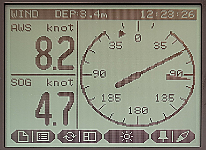
Upwind marker: On the Wind page, the circle is scaled in the quarter-second range only as far as the boat can turn in the upwind direction. This indicates to the helmsman if the boat is too sharp in quarter wind, i.e. it is pressing. The Upwind Marker can be set from the Settings menu.
Waypoints: Option to create extended amount of waypoints.
Man overboard (MOB): Quickly press the F4 function key twice to instantly pin a waypoint, automatically start navigation and switch to the BTW page, where the pointer will point to the pinned coordinate. It's recommended to set DTW and VTW on this page, so you can see how far you are from the coordinate and how fast you are approaching it. You can also set a new coordinate on the instrument by pressing the F4 function key once on the instrument. Navigation between existing coordinates is still done by long pressing F4.
BTW on the Wind page: The heading of the set coordinate is displayed on the Wind page. This will display the following indicators on the Wind page: Large Indicator: AWA (Apparent Wind Direction) Medium Indicator: TWA (True Wind Direction) Smallest Indicator: BTW (Bearing To Waypoint).
Updated brightness levels: By pressing the F3 button repeatedly, the contrast and brightness will gradually increase and then decrease until the maximum value is reached. The minimum brightness value has been lowered based on customer feedback for better night time orientation.
Settings menu: Settings menu has been updated. Factory reset option was added to reset the Settings submenu to default.
Windwiser Tools app:
When updating firmware, it is no longer necessary to download the new version from the website, as it will automatically appear in the app.
Uploading waypoints has also been simplified and all three coordinate formats (DM, DMS, Decimal) can be set.
